

Brief description and goals of the project
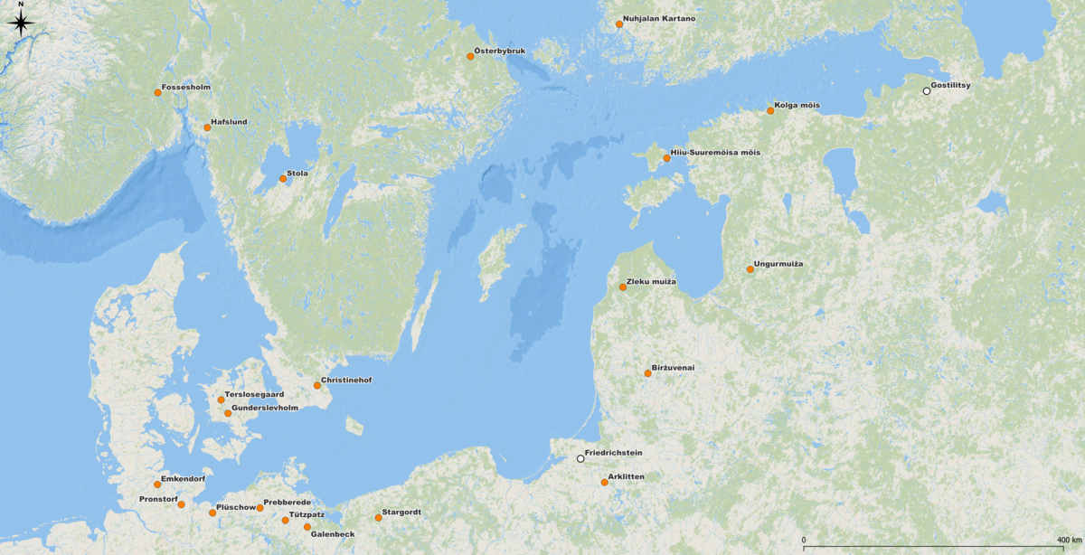
The research project is concerned with the digital recording and interdisciplinary study of manor houses and their estates in the Baltic Sea region from 1650 onwards. These estates still form a central part of the unique cultural landscape of the Baltic Sea region today.
Today, the numerous estates are spread across a total of ten countries (Germany, Poland, the Russian regions of Kaliningrad, Ingermanland and Karelia*, Lithuania, Latvia, Estonia, Finland, Sweden, Denmark and also Norway). Although the corpus of manor houses in the Baltic Sea region is perceived by architectural historians as a regional speciality, awareness of the common historical cultural landscape is nevertheless only slowly developing.
The project is funded in equal parts by the Ministry of Science, Culture, Federal and European Affairs of Mecklenburg-Vorpommern and the Federal Government Commissioner for Culture and the Media.
In the three-year funding phase, research will focus on selected objects from the 18th century, a heyday of manor houses and estates in the Baltic region. Both still existing and already lost objects will be examined. The detailed analyses not only deal with questions of art, architecture and garden history, but also integrate cultural, functional, sociological and political aspects. Using the methods of cultural transfer research and other innovative approaches in the humanities, the project will investigate how transnational political and economic relations were also reflected at the level of architecture and visual arts and how transcultural influences within Europe become visible.
The project will build a research environment that is in line with today's scientific and state-of-the-art technology. The tools of the digital humanities enable a new kind of perception through the structured processing of data and their comprehensive visualisation. This new form of contextual research will generate added value for the reception of the manor house landscape. In the project, a web portal is being created in cooperation with the Technical Information Library (TIB) Hannover, which visualises the real rooms on the web. The interior and exterior spaces and the surrounding landscape will be made tangible in their entirety, and the social, historical and economic context of the complexes will also be made clear. This opens up an innovative approach to art history and cultural landscape research.
* Due to the war of aggression in Ukraine, all cooperation with Russia is currently suspended.


The project has essentially set itself the following goals:
Collection of basic data on all manor houses in the Baltic region in general and detailed documentation of approx. 20 selected reference objects from the 18 th century.
communication of the results via a web portal
Ongoing presentation of the results via conferences and workshops as well as short reports on activities in social media and on the project homepage
Identification of suitable after-use concepts and applications (apps, mixed reality)
- Linking the project to already existing and established research initiatives in the Baltic Sea region for sustainable networking
Details on procedures, methods and web portal
Drone flights provide the scientists with initial findings in the exploration of the entire estate situation that go far beyond the publicly provided data. Equipped with RGB or multispectral cameras, the selected landscapes are systematically flown over and documented with high-resolution images. The GPS orientation of the camera system enables the processing systems to reconstruct the spatial camera perspective from the coordinates. The totality of the data forms the basis for calculations of digital landscape models on a photogrammetric basis, which enables the researchers to make a comprehensive assessment of the actual situation.
For further assessments, the scientists are provided with various visualisations from the data of the Airborne Laserscanning programme. The "airborne laser scanning" method is used to directly record height information of the earth's surface over a large area. Laser pulses are emitted from an aircraft, which are scattered and reflected by the terrain surface or objects on it (e.g. buildings, trees). These "activities" are received again by a corresponding sensor in the laser scanner. Through the GPS orientation of the receiver, an exact three-dimensional coordinate (x, y, z) is calculated for each reflection point, which is used for further processing and preparation. At the beginning, the researchers will work exemplarily with data from the state of Mecklenburg-Vorpommern. However, the investigations will soon be supplemented by data sets from the other riparian states, if available.
Digitised and analogue maps serve as an indispensable source of information, especially about historical events that no longer exist in the present landscape. They provide a view into the past and make it possible to compare the obtained view of the actual state with different situations of the war state and thus draw conclusions about events within the estate history. By combining the data obtained, different focus-oriented visualisations can be realised within a Geographic Informations System (GIS).
The researchers of the Manor House Centre receive extensive support from the team AG Fernerkundung und Geoinformationsverarbeitung of the Institute for Geography and Geology at the University of Greifswald, which works closely with the Manor House Centre.
In order to investigate the structures and features identified in the landscape model more intensively, geophysical prospection methods are used in the project. These methods of non-destructive ground investigation are increasingly used in archaeology in addition to the main field of geology. For architectural and garden historical questions within art history, however, the number of applications is still very manageable. Here, the project would like to make a contribution to establishing the methods within the discipline.
Both magnetic and ground-penetrating radar measurements are used. In magnetic prospection, small-scale magnetic anomalies are recorded that create structures in relation to the earth's magnetic field. In ground penetrating radar surveys, electromagnetic pulses are sent into the ground using a transmitter antenna. These are reflected by structures in the ground. The reflection is registered and recorded by a receiver. At the same time, the soil material absorbs or dampens the intensity of the pulse, which can also be recorded. The results of both methods can be visualised in 2D and 3D and combined with the landscape models.
For the execution of the geophysical measurements, the Manor House Centre is seeking cooperation with the Vienna Institute for Archaeological Science of the Faculty of Historical and Cultural Sciences of the University of Vienna and the Central Institute for Meteorology and Geodynamics Vienna. Meteorology and Geodynamics Vienna. The researchers are world leaders in the field of virtual archaeology and will enrich the project in any case. Initial test measurements have already been carried out and confirmed the great added value for answering relevant art historical questions.
The web portal is based on software solutions from Wikimedia Deutschland both in the backend and in the frontend. The backend uses a Wikibase instance, which is used to semantically record the collected data. Behind this is a customised data model. This can also be mapped to existing models (Wikidata) or ontologies (CIDOC CRM). By integrating the Kompakkt 3D viewer into the workflow, the data of the imaging procedures can be entered and annotated. The frontend uses a Semantic MediaWiki as a basis. It is used for the user-oriented presentation of the contents. Information from the backend is retrieved via this interface and visualised accordingly in templates. In addition to classic searches, there are location- and person-centred searches to serve the different interests of the users. In addition, the data from the imaging procedures are not only integrated illustratively, but interactively. They serve as annotated orientation markers and should trigger a feeling of spatial perception in the visitors.
You can also download a summary of all the information on the project in the form of a brochure.